
|
3 POSITION OF CELESTIAL BODIES ON THE CELESTIAL SPHERE
7. HOUR ANGLES
For navigational purposes, the position of a celestial body can be considered fixed in the celestial sphere in relation to the celestial equator and a particular celestial meridian, in the same way that the position of a place on Earth is fixed in relation to the terrestrial equator and the particular meridian through Greenwich.
The particular celestial meridian chosen as a reference point in Astro-navigation depends on upon whether the celestial body is a so-called fixed or so-called moving body (none of them is absolutely fixed). The stars, because of their immense distances from the Earth, maintain their relative positions, one with the other, on the celestial sphere.
The Sun and planets, because of their proximity to the Earth, and because of the Earth’s orbital movement around the Sun, alter their positions on the celestial sphere from day to day.
The rotation of the Earth about its own axis once every 24 hours must itself produce a change of 360º every 24 hours in the ‘long’ of a celestial body, even if this rotation is the only relative movement between the Earth and the body.
If, as in the case of the Sun, the Moon or a planet there is some additional relative movement this too will produce its effect on the body’s Longitude. It should be at once apparent that the celestial equivalent of what we call Longitude on the Earth’s surface is closely connected with time and in fact this quantity is called an Hour Angle, and celestial meridians are sometimes known as hour circles. This is because they are a measure of time that has elapsed since the body was on a particular celestial meridian.
In terrestrial navigation, only one meridian is used as a reference meridian from which to measure Longitude – the Greenwich meridian, but in Astro-navigation three celestial meridians are used to measure Hour Angles, the celestial equivalent of Longitude The celestial meridians used as references for Hour Angles are: –
- The meridian that passes through the F.P. of Aries – (used for the so-called fixed bodies – the stars)
- The Meridian of Greenwich – (used for the so-called ‘moving bodies’, the Sun, Moon,
- and planets)
- The Meridian of the Observer (used for all bodies.
8. SIDEREAL HOUR ANGLE (S.H.A.)
The sidereal hour angle (S.H.A.). of a body is the angle at the celestial pole measured westwards from the meridian of the F.P. of Aries to the celestial meridian of the body.
 In Fig 3-1., it is thus the angle at the celestial pole ♈︎ PR, or the angular distance along the celestial equator ♈︎ R, and it is expressed in units of arc (degrees, minutes, and tenths of minutes). X is the position of a star and PXRP1 the celestial meridian or hour circle on which it lies. The celestial meridian P ♈︎ P1 is the hour circle passing through the F.P. of Aries.
The sidereal hour angles of 173 stars are tabulated for each month in the N.A., arranged in order of S.H.A. However, 57 selected stars, arranged in alphabetical order, are shown in the daily pages of the N.A., these stars being chosen for their brightness and distribution in the sky. The list of 57 selected stars can be seen on pages 4, 6, and 8 of the pamphlet Extracts from the N.A. supplied with this ‘Ocean Navigation’ study.
9. LOCAL HOUR ANGLE (L.H.A.)
In Fig 3-2., POP1 is the observer’s celestial meridian corresponding to the terrestrial meridian on which the observer is situated. C is the centre of the Earth (and of the celestial sphere) and OQ is part of the celestial equator or equinoctial. X is the position of a body on the celestial sphere and PXQP1 is the celestial meridian or hour circle passing through the body.
The L.H.A. of the body X is, therefore, the angle at the celestial pole OPQ or the angular length of the arc OQ on the celestial equator. In defining the celestial sphere we explained that to an observer on the Earth, the Earth’s steady rotation from W. to E.
resulted in an apparent and equally steady rotation of the celestial sphere from E. to W.
During one rotation of the Earth in 24 hours, the L.H.A. of a body, which is fixed in the celestial sphere, will increase from 0°, when the celestial body is on the observer’s meridian, to 360° when it returns to his meridian. The hour angle of a celestial body thus increases steadily throughout the day.
10. GREENWICH HOUR ANGLE (G.H.A.)
The Greenwich Hour Angle (G.H.A.) of a body is the angle at the celestial pole, measured westwards from the Greenwich celestial meridian to the celestial meridian or hour circle on which the celestial body is situated. It is measured in units of arc (degrees, minutes, and tenths of minutes) from 0° – 360°, or in units of time (hours and minutes) from 0h – 24h, as convenience suggests.
Thus, it the observer happens to be on the meridian of Greenwich, the G.H.A., and the L.H.A. would be the same.
 In fig 3-3., P is the celestial pole and X ♈︎ OG part of the celestial equator or equinoctial. PG is the celestial meridian of Greenwich, PO the celestial meridian of an observer, P ♈︎ the celestial meridian of the F.P. of Aries and PX, the celestial meridian of the celestial body then:
Angle GPX (or arc GX) = G.H.A. of ✴︎
Angle OPX (or arc OX) = L.H.A. of ✴︎
Angle PX (or arc .X) = S.H.A. of ✴︎
It should be noted that, unlike terrestrial Longitude (which is measured both E. and W. of the reference meridian of Greenwich), all hour angles (S.H.A. G.H.A. & L.H.A.) are measured ONLY WESTWARDS from their respective reference meridians.
However, inspection of fig 3-3. will show that the L.H.A. of a celestial body can be found by applying the terrestrial Longitude of the observer’s meridian to the G.H.A.
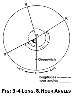
Fig 3-4., is drawn on the plane of the celestial equator (or equinoctial), that is as if the celestial sphere wore viewed from directly above the celestial pole (P in the centre of the diagram) so that the outer circle (HKGX) is the celestial equator. PX is the meridian of a celestial body, PG is the meridian of Greenwich, PK is the meridian of an observer E. of the Greenwich meridian, and PH is the meridian of an observer W. of the Greenwich meridian.
In the case of the observer E. of the Greenwich meridian: – In the case of an observer W. of the Greenwich meridian (on meridian PH):

(Since the addition of 360° does not affect the actual angular distance)
Thus to find the L.H.A.. of a celestial body from it’s G.H.A.., E. Long. is always added (- 360° from the resulting sum when necessary), and W. Long. is always subtracted (360° being added when necessary).
 To sum up: – L.H.A. = G.H.A. + E. Long. : L.H.A. = G.H.A. – W. Long.
In fig 3-4., if the G.H.A. of the celestial body on PX is known to be 062° 39.0 and the Long. of the observer on PH is 164° 47.0 W and the Long. of the observer on PK is 21° 13.0 E., then: –

The G.H.A. of the Sun, Moon, Aries and the four navigational planets, Venus ♀Mars ♂ Jupiter ♃ and Saturn ♄ are tabulated for every hour of G.M.T. on the daily pages of The N.A. and interpolation tables are provided for finding the value of intermediate times.
11. DECLINATION (DEC.)
The celestial equivalent of terrestrial Lat. is called Dec.. Lat. is simply the angle, measured at the centre of the Earth (which is also the centre of the celestial sphere), between the celestial equator and the celestial body, measured either N. or S. of the celestial equator in the plane of the celestial meridian through the body.
A Parallel of Dec. corresponds to a Parallel of Lat. on the Earth’s surface and is a small circle on the celestial sphere, the plane of which is parallel to the plane of the celestial equator.
In fig 3-5., P is the N. celestial pole, C♈︎B is the celestial equator or equinoctial, PYC is the celestial meridian of a body Y, and PXB is the celestial meridian of the body X.
Then: – Arc BX = Dec. of body X (N.)
Arc CY = Dec. of body Y (N.)
Arc ♈︎ C = S.H.A. of body Y
Arc ♈︎ CB = S.H.A. of body X
The dotted circle through Y is the parallel of Dec. of Y, and the diagram also shows a parallel of S. Dec., S. of the celestial equator. N. or S. as the case may be, is called the NAME of the Dec. If two bodies are both of N. or both of S. Dec., the Declinations are said to be the SAME NAME.
If one is N. and the other S. they are said to be of OPPOSITE or CONTRARY NAME.
The declinations of the star’s change very slowly and, like their sidereal hour angles may be considered constant for up to about one month. Declinations for the 57 selected stars in the N.A. are tabulated in columns adjacent to the S.H.A.’s on the daily pages. (See pages 4, 6, and 8 of the ASTRO-NAVIGATION PAMPHLET).
The Dec. of the Sun, however, changes from 23½°N to 23½°S. and back again during twelve months. The declinations of the four navigational planets, Venus ♀Mars ♂ Jupiter♃and Saturn♄and of the Moon also vary between wide limits. The declinations of the Sun, Moon, and Planets are therefore tabulated directly on the daily pages of the N.A. for every hour of G.M.T., and Interpolation Tables provided to find their values at other times.
12. POLAR DISTANCE
The polar distance is the angular distance of a celestial body from the elevated pole measured along the body’s celestial meridian. The elevated pole is the pole above the observer’s horizon. In fig. 3-5, the polar distance of body X is PX and of the body, Y is PY if the observer is assumed to be in N. Lat. When the elevated pole and the Dec. have the same names, the polar distance is clearly 90° – Dec. When they have opposite names, the polar distance is 90° + Dec.
13. RELATIONSHIP BETWEEN – THEORETICAL AXES – & – PRACTICAL AXES
Although the position of a celestial body has been defined in the celestial sphere by its Dec. and hour angle, these angular distances are measured from theoretical axes. The navigator, for his own convenience, when he wishes to measure and define the position of a particular celestial body, he will employ more practical axes – his own meridian and the sea horizon. He will then decide the celestial body’s position by a bearing from the meridian and an altitude above the horizon.
The fundamental feature of Astro-navigation is the relating of the celestial position of a body at a given instant of time using the horizon system, with its position at the same instant of time using the equinoctial system.
The coordinates of the horizon system are altitude and azimuth (now to be explained) and the coordinates of the equinoctial system are Dec. and hour angle.
A navigator is concerned not only with the altitude of a body above the horizon, which he actually sees (the sea horizon) but also with its altitude above the celestial horizon. As will be shown in § 09-13, having measured the altitude above the sea horizon, he applies certain corrections until it refers to the altitude above the celestial horizon.
 14. THE HORIZON SYSTEM OF CELESTIAL MEASUREMENT
 14. THE HORIZON SYSTEM OF CELESTIAL MEASUREMENT
As explained in the previous section, the Horizon system is the one used by a navigator to measure the position of a celestial body, and the coordinates used in this system are illustrated by fig. 3-6. In this diagram, as before, the inner sphere represents the Earth and the outer sphere the Celestial Sphere, 0 in the centre of the Earth and of both spheres, while p and p1 are the Earth’s poles and P and P1 the celestial poles.
The great circle on the Earth’s surface qq1 is the equator, and QQ1 on the celestial sphere is the celestial equator or equinoctial. 0 is the position of an observer on the Earth’s surface.
The Observers Zenith (Z) is the point on the celestial sphere vertically above the observer, and may be defined as that point where a straight line from the Earth’s centre passing through the observer’s position cuts the celestial sphere.
The Dec. of the zenith (QZ) must, therefore, be equal to the observer’s Lat. (qO).
Only about half of the celestial sphere is visible to anyone observer at any one instant, owing to the Earth itself obscuring the observer’s view. Thus the observer at 0 in fig. 3-6 can only see that part of the celestial sphere, which lies above the great circle NWSE.
This great circle is called the Celestial or Rational Horizon and may be defined as that great circle on the celestial sphere every point of which is 90° from the observer’s zenith. A plane through the centre of the Earth at right angles to the Observer’s radius CO would cut the celestial sphere in this great circle.
The celestial horizon, therefore, divides the celestial sphere into two hemispheres, the upper one of which, containing the zenith Z, is known as the visible hemisphere because all celestial bodies in this half of the celestial sphere are visible to the observer at 0. Celestial bodies in the lower hemisphere (shaded in fig. 3-6) cannot be seen.
All great circles passing through the observer’s zenith are necessary perpendicular to the celestial horizon and are known as vertical circles. The particular vertical circle passing through the E. and W. points is called the prime_vertical (EZWZ1 in fig. 3-6). Another vertical circle is the Observer’s meridian. This is the celestial meridian that passes through the observer’s zenith. The observer’s celestial meridian is divided into two parts each of 180° and each part terminates at the celestial poles. The part on which is situated the observer’s zenith (PZQSP1 in fig. 3-6) is known as the observer’s upper meridian and the other part (PNQ1Z1P1) is known as the observer’s lower meridian.
The points N and S in which these two meridians cut the celestial horizon are the N. and S. points, the N. point being the one nearer the N. Pole. The observer’s meridian is sometimes called the principal vertical circle because it provides a fixed reference in the celestial sphere just as the observer’s terrestrial meridian provides one on the Earth’s surface, but this should not be confused with the prime vertical described above.
We have said that the coordinates used by the navigator in the horizon system are altitude and azimuth. The True. Alt. of a celestial body is the angular distance of the body above the celestial horizon, measured along the vertical circle through the body and the observer’s zenith.
 It will be seen that fig. 3-7 is substantially the same figure as fig. 3-6 but, for convenience, the Earth and the observer are indicated by the single point 0, and the vertical circle passing through a celestial body X has been substituted for the prime vertical.The True. Alt. of the body X is, therefore, the arc AX, or the angle AOX (the angle at the Earth’s centre between the celestial horizon and the body X in the plane of the vertical circle (ZXAZ1) through the body).
Because the celestial or rational horizon is not the same as the sea horizon, which the navigator actually sees, he cannot measure the True. Alt. directly, but as will be shown in § 9-13, by applying certain corrections to the altitude of a celestial body that he measures with his sextant, he can calculate the True. Alt.
Once the altitude, AX in fig. 3-7 has been obtained by the use of the appropriate correction, the distance of the celestial body from the observer’s zenith can be found (ZX). This is simply 90° – True. Alt. (ZA-AX) and is called the Zenith Distance. It is most important because it is a component of the navigational triangle PZX.
Another component of the navigational triangle is the Azimuth of the celestial body. This is the angle at the zenith between the observer’s meridian and the vertical circle through the celestial body, and it is measured E. or W. from his meridian, from 0° to 180°, and named N or S from the elevated pole.
 The azimuth of the body X in fig. 3-7 is the angle PZX, shown shaded. Since the azimuth of a celestial body is measured E. or W. from the meridian and named from the elevated pole, it is not always the same as the true bearing of the celestial body, which would be measured clockwise from true N. For instance, the azimuth of X in fig. 3-8 is N. 60° W., but the true bearing of X is 300° True. An azimuth cannot be greater than 180°.
To sum up the horizon system of celestial measurement, consider fig. 3-8 where it will be seen that:

(in quadrantal notation) or arc NAESB in 3-figure notation. (Note that although the azimuth of Y is named from N., the bearing of a point is named from the nearer of N. or S. towards E. or W. in quadrantal notation, so that if the azimuth of Y is N.110° W., the bearing of Y would be S.70° W. in quadrantal notation, or 250° T in 3-figure notation)
|