
|
44 TEMPERATURE AND STABILITY OF THE ATMOSPHERE
168. TEMPERATURE AND HEAT
Of all the many elements of weather, the temperature is probably the most important, because changes of temperature in the atmosphere largely control both the wind and the concentration of water vapour in the air and these two, in turn, are important in determining the formation of clouds and rain.
Temperature is sometimes described as the degree of hotness or coldness of a substance, but a better and more revealing way of looking at it is as thermal potential, analogous to electrical potential. When it is remembered that heat is energy in a particular form, the difference between temperature and heat can be appreciated. Temperature is measured with a thermometer, of which many types exist, but those most commonly used in meteorology measure the change in size of some standard substance, such as mercury or spirit in a glass tube, or by the change in length of metals having different coefficients of expansion welded side by side.
Temperature is expressed by means of one of three scales, Celsius (°C.), Fahrenheit (°F.) and Kelvin (K). All three of these scales are in common use in Meteorology and conversion from one to the other should be understood, but the Fahrenheit scale is gradually being dropped in favour of the other two. A temperature scale is fixed firstly by two points, the freezing and boiling points of water under standard atmospheric pressure.
For the Celsius scale, the range between the two points is divided into 100 equal parts, called degrees and the numbers 0 and 100 were chosen to represent the freezing and boiling points respectively. Temperatures below freezing are less than zero and must be expressed as negative numbers. On the Fahrenheit scale, freezing point is 32°F., and boiling point 212°F., so that the Fahrenheit degree is only 5/9 of the Celsius degree.
For scientific purposes, the Kelvin scale is used. The international (SI) unit of temperature is the Kelvin (K). It is defined as the fraction 1/273.16 of the thermodynamic temperature of the triple point of water, the triple point of a substance being the pressure/temperature condition, unique for a given substance, at which the substance may exist in the solid, liquid or gaseous state. On this scale, water freezes at 273.15K. and boils (at standard pressure) at 373.15K. For meteorological purposes, K = 273 + °C., where C is Celsius temperature.
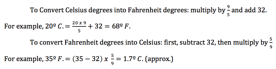
To convert Celsius degrees into Kelvins: add 273. To convert Kelvins into Celsius degrees: subtract 273.
169. Heat Transfer Processes
When two bodies having different temperatures are placed near each other, heat flows between them and there is a tendency for the two temperatures to become equal. This transfer of heat may take place in three ways – by conduction, by convection and by radiation.

Conduction is the transfer of heat by contact; when the sun is shining on and, therefore, warming the Earth, the air in contact with the Earth’s surface is warmed by conduction. Convection is the interchange of heat by warm currents of gas or liquid; free convection occurs when the gas or liquid is heated from below, so that parts of it become less dense and, therefore, buoyant, and rise as upward-flowing currents, replenished by adjacent downward currents, as in the formation of convection cloud and sea breezes (see fig. 44-1). Forced convection or turbulence is the transfer of heat by agitation or mixing when the unequal heating of the different substances of the Earth’s surface causes an irregular vertical and horizontal movement of the air above it, leading to a through mixing of the warm surface-air with the colder air above, when the wind is fresh or strong.
Heat can flow between two bodies even when they are not in contact, in the form of electro-magnetic radiation. This method does not require the presence of an intervening material medium, but if one is present, it may alter the process. All bodies emit radiation continuously in the form of waves similar to radio waves, but usually with much shorter wavelengths, and hot bodies radiate very much more intensely than cold bodies. The ‘first cause’ of weather is the radiation received from the sun. Sunlight is composed of-the colours of the rainbow and the wavelengths are expressed in microns (one millionth part of a metre). Only a limited range of wavelengths can be detected by the eye in the form of light, namely those lying between the approximate limits 0.4 micron for violet light, through blue, green, yellow and orange, to 0.7 micron for red light. When a body radiates, there is a wavelength for which the energy is greatest, falling off for the wavelengths on either side. The higher the temperature of the body, the shorter the wavelength corresponding to maximum energy. For the Sun, this wavelength is about 0.5 micron (blue-green light), corresponding to a temperature of about 6,000°C. Like all material bodies, the Earth also radiates; its average temperature is about 15°C., so that its maximum energy wavelength is 10 microns – invisible, but detectable as heat. The Sun’s radiation is referred to as short wave, and the radiation emitted by the Earth as long wave.
 The Sun radiates energy at a rate which, for practical purposes, is unchanging at about 1.35 kilowatts per square metre of surface perpendicular to the beam; this is called the Solar Constant. However, the intensity of radiation found at the Earth’s surface is not constant, because some radiation is lost whilst passing through the atmosphere and because of the changing elevation of the Sun. This latter cause is illustrated by figure 44-2, in which rays a and b, which reach the Earth from directly overhead, are concentrated on an area the width of which is AB, whereas the same number of rays or amount of radiant energy cd (the distance apart of c from d equals that of a from b) striking the Earth obliquely, will be distributed over an area whose width is AB’
Thus, more radiation heat is imparted to the same area when the elevation of the Sun is high, than when it is low. The Sun’s elevation depends upon the time of day, the season and the latitude, so the intensity of radiation is relatively weak near sunrise or sunset, in winter and at high latitudes.
The losses incurred as solar radiation passes through the atmosphere are caused by: –
- Absorption (about 15%) – especially by water vapour and ozone;
- Scattering [about 10%) – the alteration of the direction of the radiation as it passes near to air molecules;
- Reflection (about 30%) – from clouds and from the ground (especially when snow- or ice-covered).
The total effect is that only about 45% of the radiation entering the Earth’s atmosphere is absorbed by the ground.
170. The Heating of the Atmosphere
 All three methods of heat transfer are active in heating the atmosphere and are shown diagrammatically in fig. 44-3. Radiation from the Sun passes through the atmosphere with some depletion, resulting from absorption, scattering and reflection, the remainder being absorbed by the ground which thus becomes hotter. As soon as it becomes hotter than the air above it, heat flows by conduction and the air becomes warmer. Because of its poor conductivity, this heating of the air is confined to a very shallow layer near the ground, the layers above being heated by mixing with the shallow warm layer as a result of convection or turbulence. Thus, the atmosphere is heated not by the solar rays passing through it, but by the warmed Earth’s surface.
The long wave radiation emitted by the Earth does not, however, pass freely through the atmosphere; part of it is absorbed, especially by water vapour and carbon dioxide. This warms the air which, in turn, radiates some of the heat back to Earth, and some to space. Thus, the atmosphere, by trapping some of the outgoing radiation, keeps the Earth’s surface warmer than it would otherwise be. The Moon, having no atmosphere, is subject to extremely low temperatures in the parts not in sunshine.
 The energy of radiation emitted by a body increases with its temperature; thus, a warm surface loses heat by radiation more quickly than a cold one. This accounts for the fact that the daily cycle of temperature does not exactly correspond to the daily cycle of sunshine and darkness. Radiation is received from the Sun during the period from sunrise to sunset, yet the temperature does not go on increasing all day; it reaches its highest value in the early afternoon, then decreases. This happens in spite of the fact that at 3 p.m., say, the Sun is just as high in the sky as it was at 9 a.m., and then the temperature was rising. The reason is that the Earth’s surface is constantly losing heat by radiation; the higher the temperature, the greater the rate of loss. In the early afternoon, the Earth’s radiation begins to outweigh that received from the Sun, so cooling sets in. This continues throughout the evening and night, the lowest temperature is reached at about sunrise (see fig. 44-4). The foregoing applies to land areas when the sky is clear. If there is a layer of cloud, both the incoming and the outgoing radiation are restricted; the same kind of temperature cycle occurs, but it is less pronounced, the days being cooler and the nights warmer. Clear nights in winter have sharp frosts; cloudy nights are, as a rule, less cold.
Over the sea, the difference between day and night temperatures is much less than over land. This is because in the sea the solar radiation penetrates to a considerable depth (on a calm day in clear weather, you can see the sea bottom many feet, sometimes fathoms, below the surface), whereas, over land, nearly all the solar radiation is absorbed in the top few inches of soil or rock. Moreover, the specific heat of water is nearly three times that of land, i.e. three times as much heat is required to raise the temperature of a given quantity of water by, say, one degree, than is required for the same quantity of land, so that the increase in sea surface temperature is only slight. And lastly, because the sea wave turbulence causes the heat acquired at the surface to be spread downwards. From the weather point of view, the sea surface temperature is important, because it largely determines the temperature of the air, which blows over it. Sea surface temperature seldom varies as much as 1°C. in 24 hours in any one place, even in the tropics.
Observations of coastal water temperatures show very wide variations from open sea temperatures and mud flats, sand or shingle banks when uncovered can gain or lose a lot of heat, which is either given out to the tide or taken in by it. Thus, shallow creek water may easily be 20°C. on a summer afternoon tide, while narrow waters are the first to freeze up in bleak winters. A tide which is low just before dawn on a frosty night can flood as a very cold tide in the early morning as it loses its heat to the mud, sand and shingle. This water is later taken out to sea on the outgoing stream and may lead to coastal fog developing where none would otherwise be expected.
171. Sky Colouring
It is essential in the modern theory of radiation discussed above, that matter radiates electromagnetic energy in small pockets called quanta or photons. Each photon travels at the speed of light and carries an energy which, although it is minute, depends directly on the frequency (colour) of the photon. Any visible light source emits millions of photons per second and they may be of many visual effects is, therefore, of continuous light of a colour which those photons in greatest visual profusion. For this reason, sodium street lights are predominantly yellow, because sodium emits far more yellow than any other colour.
There are two main processes by which white light from the Sun into its component colours. One of these is refraction, which needs ice crystals and raindrops of visible size on which to act. A rainbow is a typical example of refraction, in which the light rays striking the surface of the raindrops are bent internally within the drop (as in a prism). The deviation of sunlight as it drop is so great as to bend it back almost opposite to its original path and, in this process, the light is also dispersed into its constituent colours. The other process is diffraction or scattering, in which individual particles in the upper atmosphere (which may be as small as molecular size) deflect photons out of their straight paths from the Sun.
This explains the daytime blue of the sky, for the blue photons of the Sun’s visible radiation, are sixteen times more likely to be intercepted and scattered than the red. Thus, blue is scattered earthwards (as well as spacewards) as it fluxes across the sky above us, while the majority of the red races past the Earth. When the Sun is at a low altitude, however, dust in the atmosphere will scatter other colours and so dilute the primary blueness, because of the additional length and density of the atmosphere through which the sunlight must penetrate to Earth’s surface from so low an altitude. Thus, at sunrise and sunset clouds sometimes assume tinges of pink, pale green, gold or red, bec wavelength radiation has been scattered, as just described.
Pale and delicate tints at sunrise and sunset in a sky with little comparatively dry atmosphere and settled weather; such conditions are usually associated with anti-cyclonic conditions and a fairly high barometer. If the dominant colour at sunrise or sunset is a fiery or coppery red with a good deal of cloud, it is an indication of much water vapour in the atmosphere and, therefore, the likelihood that the weather is unsettled and rain and wind not far off. The familiar rhyme –
“Red sky in morning, Sailor’s warning; Red sky at night, Sailor’s delight”.
is rather misleading because, as will be appreciated from the above, it depends upon the shade of red. A low sunset (when the Sun sets on a horizon beneath a bank of clouds) is a good sign and, as a rule, heralds good weather, because if there were more middle or high clouds on their way within 100 miles, you would not be able to see the Sunset. On the other hand, a high sunset (the Sun setting behind a bank of clouds) is probably a bad sign and wind and rain are likely during the night.
172. Measuring Temperature at Sea
The small craft navigator is interested in three different temperatures for meteorological purposes at sea – the air temperature, the sea temperature and the wet-bulb temperature. The first and last of these temperatures can be taken simultaneously when a hygrometer is carried, and more details on this are given in the chapters on Basic Meteorology.
 In meteorology, it is the true air temperature which is important. A thermometer measures its own temperature – strictly, the temperature of the liquid in the bulb, and, unless certain precautions are taken, this will not be the same as the temperature of the surrounding air. For example, if a thermometer is exposed to direct sunshine or even reflected sunshine from a nearby object, it will indicate a temperature higher than the air temperature. Adequate ventilation of the thermometer bulb is also necessary because pockets of warm or cold air can form around the bulb and affect the reading. For these reasons, meteorological thermometers should be enclosed in a screen, usually, a wooden box with louvred sides called a Stevenson Screen.
The true air temperature required at sea is that a few feet above the sea surface, but from the preceding discussion of radiation, it can be understood that accurate measurement of this is very difficult when the measurement has to be made on board the craft itself. The meteorologist requires the temperature of the air as though the vessel were not there but, in practice, the whole of the vessel’s structure above the waterline is sending out long-wave radiation. Air reaching a Stevenson Screen exposed on a vessel’s cockpit or bridge is affected by this radiation and may also be contaminated by being mixed with air from galley or engine compartment ventilators. Therefore, it is most important to hang the thermometer screen on the windward side, since this ensures that the heating effect of the vessel, by radiation and conduction on the air reaching the screen, is reduced to a minimum. On very small crafts where the use of screened thermometers is impractical, a special ventilated thermometer can be used: a simple type is a whirling thermometer which is mounted in a wooden frame which swivels on a handle (rather like a football fan’s rattle). Where there is a following wind of speed equal to that of the vessel so that a relative calm exists aboard, this latter type of thermometer is superior to the screened type, providing the readings are taken as far out over the vessel’s side as possible.
For measuring sea-surface temperatures, special sheathed thermometers can be bought. These are fitted with a “sea protector” (see fig. 44-5), a metal cup or a reservoir for retaining a small quantity of seawater around the bulb while the temperature is being read.
Samples of sea water which are to be used for measuring the sea temperature should be obtained in a canvas bucket of diameter not less than 5 inches. Special canvas buckets are issued by the Meteorological Office, which has a spring lid, opening inwards at the top of the bucket; this opens to admit water when the bucket is immersed and closes again when the bucket is lifted out of the water, thereby preventing spillage.
For meteorological purposes, it is the temperature of the sea surface which is required, so care must be taken that the bucket is not lowered too deeply and also that the sample is taken well clear of any discharge pipes from the vessel.
To measure the sea surface temperature, the thermometer bulb and its sea-water reservoir should be held for a minute or so in the sample and then removed; the water in the reservoir is poured back into the sample, which is then thrown overboard. The object of this is to bring the thermometer and bucket approximately to the temperature of the sea surface. A second sample of sea water is then obtained and the bucket is lifted quickly inboard in a position which is in the shade and clear of the influence of internal warm air exhausts. The thermometer and reservoir should be dipped into the sample and moved up and down in the water until the temperature is steady; a reading should be obtained within 30 seconds of the immersion. When reading the temperature, the bucket should be raised, so that the thermometer can be read at eye level, without removing the bulb from the bucket. If impracticable to hold the bucket up, care should be taken to ensure that the reservoir is not emptied of water, so that the bulb is not exposed to the air.
All thermometers, whether used for measuring air or sea temperatures, should be examined before reading, to see if there is a break in the mercury column. If this is so, the thermometer should be swung vigorously up and down (holding the top end) until the column is again continuous. It should then be given ten minutes or so to settle down before being read.
173. Stability of the Atmosphere
As the lower atmosphere or troposphere (see Study on Basic Meteorology), derives its heat indirectly from the Sun through heating of the Earth’s surface and of the layer of air in contact with it, it is not surprising that, on the whole, the temperature of the troposphere decreases with height. The rate at which this decrease of temperature takes place is called the Lapse Rate. The average lapse rate within the troposphere is about 0.6°C., per 100 metres (or 1°F., Per 300 feet) increase in altitude. However, the temperature of the troposphere does not always and everywhere decrease with height. The temperature can sometimes, over a limited height interval, increase with height (called a negative lapse rate), and the term inversion is used to describe a layer through which the temperature increases with height. An inversion is always present, for example, just over the fog. The term “lapse rate” generally refers to the lapse rate of the environment (environmental atmosphere), and should not be confused with the “adiabatic lapse rate“ to be described below.
 Adiabatic is the name given to changes in temperature, pressure and volume, which are produced in a substance when no heat is allowed to reach it or to leave it while it is being compressed or expanded – in other words, thermally-insulated. In meteorology, when a body of air is subjected to increased pressure, it undergoes compressional heating; similarly, if the same body of air is subjected to a decrease in pressure, it undergoes expansional cooling. In both cases, no interchange of heat takes place between the body of air and the surrounding air (environmental atmosphere) and the temperature changes thus brought-about are said to be adiabatic changes. If a parcel of air rises through the environmental atmosphere, it under-goes a reduction in pressure and is cooled adiabatically. Conversely, if a parcel of air sinks through the environmental atmosphere, it undergoes an increase in pressure and is warmed adiabatically.
Air is a very bad heat conductor, so that when a small ‘parcel’ of air near the surface is given a temperature slightly above that of the surrounding air at the surface, then it retains the additional heat which it has gained and this heat is not shared with the air in its neighbourhood. (Small parcels of air often gain more heat than the surrounding air; for instance, this happens on a sunny day wherever a patch of bare rock or soil an acre or two in extent is surrounded by grassland or woodland, which does not radiate the same amount of heat). In this case, such a heated parcel of air, being less dense than the adjacent air, will rise through levels where the pressure is progressively reduced, so that it will undergo expansion. Since it does not lose (or gain) heat from the surrounding air while rising through it, the parcel of air is undergoing an expansion under adiabatic conditions. The temperature of any parcel of air cooling under these conditions, falls with increasing height at the same rate, provided the parcel is dry, i.e. unsaturated. This rate of cooling is known as the Dry Adiabatic Lapse Rate (D.A.L.R.), and has a value of approximately 10°C., per kilometre (or 5.4°F., per 100ft.) of ascent. The D.A.L.R. is constant, no matter what the original temperature of the parcel of air may be. A descending parcel of air warms at the same rate, as a result of adiabatic compression. When a parcel of saturated air similarly rises through its surroundings under adiabatic conditions, it cools at a rate which is rather less than the dry adiabatic lapse rate. This is because, while the saturated air is rising, water vapour condenses from it, releasing latent heat* which is absorbed by the rising parcel of air. Warm saturated air holds a large quantity of water vapour, cold air very little; in the warm air, a large amount of latent heat is released in the formation of cloud, and thus, the Saturated Adiabatic Lapse Rate (S.A.L.R.) is not constant, but varies between about 3°C., per kilometre (2°F., per 1,000 feet) of ascent in the moist air of tropical areas to almost 10°C., per kilometre (5.4°F., per 1,000ft.) at low temperatures and high levels in the atmosphere. On average, however, the SALR is about 6°C., per kilometre (3.S°F., per 1,000 feet) at ordinary temperatures in temperate regions (i.e. about half the dry adiabatic lapse rate). For descending saturated air, however, the initial slight warming causes the air to become unsaturated; it then behaves as dry air, its temperature rising at the DALR (10°C., per kilometre or 5.4°F., per 1,000 feet of descent).
(*Latent heat is defined as the quantity of heat absorbed or emitted without change of temperature during a change of state (e.g. from water vapour to water, water to ice) of unit mass of material).
The atmosphere is said to be stable when a parcel of air which is displaced slightly upwards or downwards is acted upon by a buoyancy force tending to restore it to its former level. Dry air is stable when its lapse rate is less than the value of the dry adiabatic lapse rate; saturated air is stable when its lapse rate is less than the value of the saturated adiabatic lapse rate.
The atmosphere is said to be it unstable when a parcel of air displaced slightly upwards or downwards is acted upon by a buoyancy force tending to move it further upwards or downwards. Dry air is unstable when its lapse rate exceeds the D.A.L.R., and saturated air is unstable when its lapse rate exceeds the S.A.L.R.
When the lapse rate of dry air is exactly equal to the D.A.L.R. through any thickness, and when the lapse rate of saturated air is similarly equal to the S.A.L.R., there is consequently no restoring force acting on a parcel of air when it is displaced either up or down, so the air in such a layer is said to be in neutral equilibrium.
Some examples may make the above definitions clearer (see also fig. 44-6). When a parcel of air near the Earth’s surface becomes slightly heated, it will begin to rise, being lighter than the surrounding air. Whether or not it will go on rising depends upon how the temperature in the surrounding (environmental) air changes with height. Suppose, for example, the air temperature near the ground is 50°F., and, at a height of 1,000ft., the air temperature is 44°F. If the parcel of dry air is warmed to 51°F., it will begin to rise and its temperature will fall at 5.4°F., per 1,000ft. (the D.A.L.R.), so that when it reaches a height of 1,000ft., its temperature will be 51° F., less 5.4° ; that is, 45.6° F. It will then be air at the same level and will, therefore, continue to rise. The atmosphere in these circumstances would, therefore, be said to be unstable, because the environmental lapse rate is greater than the D.A.L.R. Now, suppose that the environmental lapse rate is less than the D.A.L.R., for example that the temperature at 1,000ft. is 47°F. The rising parcel of air at 1,000ft., temperature 45.6°F., is now colder and, therefore, heavier than the surrounding air, and it will fall back to its original position. In this case, the atmosphere is said to be stable. The D.A.L.R. is, therefore, critical, in the sense that if in the atmosphere this lapse rate is exceeded, the rising and falling motion of parcels of air is sustained; otherwise, it is suppressed.
These arguments regarding stability and instability for dry air may be repeated for rising saturated air, except that the critical lapse rate is the S.A.L.R. in this case. ,
If the heating of the air near the surface is maintained, for example by the Sun heating a patch of dry, bare earth, there will result not a single parcel of rising air, but a continuous upward current called a thermal (often utilised by glider pilots to maintain or increase the glider’s height). If a parcel of rising air is unsaturated, it will, to begin with, behave like rising dry air. But, at some stage, it will be cooled to its dew point and, thereafter, behave like saturated air. This is what usually happens in the atmosphere. The moisture condensing out of the rising cooling air becomes visible as a cloud, usually Cumulus. These clouds are useful to glider pilots, because they mark the tops of thermals. If the atmosphere is unstable and the upward current goes on rising to very great heights, the result becomes the towering Cumulonimbus or thundercloud.
An environmental lapse rate equal to or exceeding the S.A.L.R. must usually exist throughout a depth of about 10,000ft., to ensure that Cumulonimbus clouds can become thick enough to allow showers to develop; similarly, the saturated adiabatic layer must be about 15,000ft. deep to result in the formation of thunderstorms. If, as often happens, the lapse rate beneath the condensation level is less than the D.A.L.R. and the air there is not saturated, Cumulus clouds will not form until a D.A.L.R. has been established through the whole layer below the condensation level, which will not happen until this layer has received a certain amount of heating from below.
It sometimes happens that the environmental lapse rate is negative, i.e. the temperature in the atmosphere increases with height through a limited layer, which may rest on the earth’s surface or occur at some upper level. This is called an inversion, an extremely stable state, and it strongly damps-out any tendency for rising or descending air currents. When the lapse rate is less than the S.A.L.R., especially when there is an inversion a short distance above the ground, convection currents cannot occur and the formation of convection cloud is prevented. Inversions are common near the ground around sunrise, following a clear night and, if the day following is clear, after several hours of sunshine the lowest layers of the atmosphere will often be warmed sufficiently to establish a D.A.L.R. to a height above the condensation level, when convection cloud will be formed. In general, stratiform (layer-type) cloud is associated with a stable atmosphere; cumuliform cloud of considerable vertical extent is associated with an unstable atmosphere.
Stable and unstable air have been discussed above in terms of the behaviour of small parcels of air displaced upwards or downwards from their initial level. However, under some conditions, such as in the lower layers of a stationary anti-cyclone, there is a considerable horizontal outflow of air over a large area which exceeds the horizontal inflow at the same level, this condition being called divergence. This air must be replaced by air slowly descending from higher levels: the process of such descent is called subsidence.
When air subsides (i.e. descends), it is always warmed at the D.A.L.R., even when originally saturated (as explained earlier). The moisture-content is not changed by the descent, so the relative humidity must decrease as the temperature of the subsiding air rises, and subsidence areas are, therefore, occupied by warm, relatively-dry air. Subsidence also alters the lapse rate, increasing the stability of originally-stable subsidence continues strongest inversions surface temperatures air and resulting in the development of an inversion, if the for long enough (i.e. for one or two days or are subsidence inversions where air has sunk rising to 20°C., or 30°C., (7O°F., to 80°F.) This is usually associated with quiet, settled conditions such as area of an intense summer anti-cyclone.
|